|
Distinctive features of fire dynamics in Sakhalin 1998
|
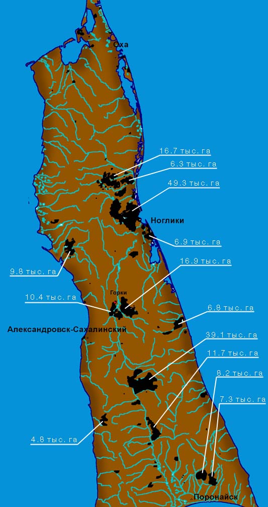
| | Pic. 5. Major forest fires in Sakhalin in 1998 (burnt-out areas of non-forest lands are not included). |
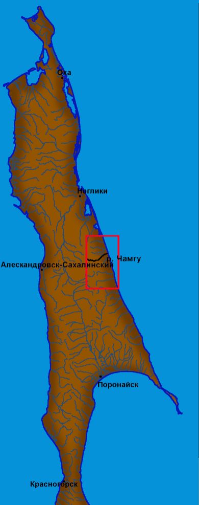
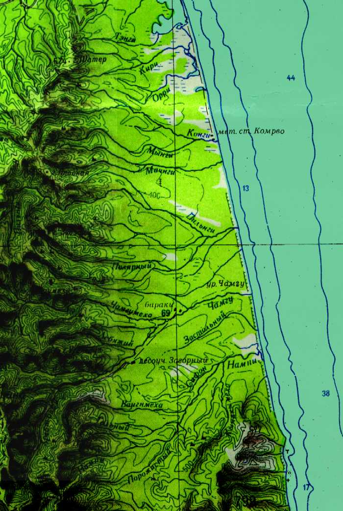
During the 1998 fire season, the situation became aggravated beginning in early May - after the rain stopped and a spell of hot, dry weather descended upon major part of central and northern Sakhalin. The first considerable out-break was registered near the Chamgu river, where recent clear cuttings had been done. That fire, varying in intensity, was very expansive and didn't stop until late November. Almost the entire basin of the Chamgu river was burnt out. The fire passed along its tributaries up to the Nobilsky Ridge mountains. It damaged considerable areas of mountain forests of dwarf Siberian pine and plant communities outside the upper forest boundary. According to witnesses, the Chamgu River used to be one of the most beautiful and abundant salmon spawning rivers in the region. After that fire,the River was destroyed.
From mid to late May, forest fires grew more intense in the Central and Northern Sakhalin. An abnormal rainfall shortage in the region during the summer months made the fire situation grow worse and caused ignitionsand spreading of fire. In June, the worst situation was seen in the Nogliki and Smirnykhovsk Regions Other regions were able to stop some fires. Although the forest servicemen were aware, that the undamaged forest can be saved by heavy downpour alone. A lack of rain caused the inevitable spread of fire over all "dry" regions. In June, the Chamgu Region fire expanded into neighboring areas and basins of other rivers. The forest service managed to contain the southward expansion, however, the fire in the North went out of control and continued to spread throughout the Nogliki Region, where the forest had been recently clear cut, further contributing to the fire expansion. In the middle of July, the Sakhalin Forest Department started to take special measures - they urgently requested an amphibian plane, BE-12P, from Irkutsk. However, it didn't work effectively, mostly due to uncoordinated activities of different agencies and partly due to the plane crew being unprepared to work on Sakhalin. In the meantime, fire ran through other regions, including Uglegorsky and then Poronajsky and Tymovsky. By early August, it struck Okhinsky and Alexandrovsk-Sakhalinsky Regions as well. People couldn't fight the fires in many areas because of the difficult terrain - the machines couldn't work on steep slopes. In some cases, the forest service was not able to call forth enough personnel and means to respond to the alarm, which was often delayed. Many times strong winds exacerbated the situation. The small amount of rainfall in August couldn't fight the danger. According to decision makers in the Sakhalin Forest Department, by August 5, in the northern part of the Island, the rate of fire probability was high even in the forests, which are usually considered to be of the lowest class of fire danger. Local forest officials claimed many times that the degree of fire damage and the tense fire situation exceeded the Sakhalin's forest catastrophe in the 50-ies. In mid August, minor fire sites were registered in Korsakovsky and Kholmsky Regions.
The situation grew drastically worse in September mainly due to heavy winds that swept over Northern Sakhalin, multiplied by severe dryness and no rainfall. On some days, the number of fire sites grew tenfold. Exhausted by continuous work, shortages of equipment, fuel and funds, forest service personnel and the local administration, as well as logging enterprises, were unable to control the fires. It became vital to protect the people living in taiga communities - the fire reached some of their outskirts. People in most of the communities of Tym-Poronajsky Lowland, breathed harsh smoke, that lingered over them. The concentration of carbonyl in the air exceeded established norms many times. The sun was fighting its way through the smoke screen and day turned into dusk.
Based on satellite images, by early September 1998, over 24 thousand hectares of forest lands were burnt. By September 25, this number was not less than 106 thousand hectares. The end of the year was far more dramatic - over 234.8 thousand hectares were destroyed.
Forests of Nogliki, Ado-Tymovo-Gorki, Longary-Jasnoje Regions suffered most.
(Picture 5).
The fire situation in Ado-Tymovo-Gorki had a very specific development (this is one of the regions that attracted the attention of local and central media). Considering the fact that promptness and exactness of locating the identified fire sites with topographical maps at the time of fire analysis was becoming less significant, the matching was carried out using a simplified technique. NOAA images were used and the exactness of matching makes up approx. 1. 0 - 1. 2 km. It is necessary to point out, that we used a conventional topographic map having a scale of 1:500,000, which is itself characterized by certain errors and imprecision.
According to the satellite, by September 11, in the middle current of the Vosja River (one of the right-hand tributaries of the Tym river) we registered a minor fire site and approximately 280 ha of burnt forest.
By September 23, the burnt area along both Vosja banks was about 440 ha. The intense ground fires were dominating. At the same time, vast areas in the vicinity of Ado-Tymovo community were also burned - between the Tym river, railways to Nogliki, Ado-Tymovo community and the road to the west coast. The area of those sites made up 1,360 ha. The ignition of this fire took place a couple kilometers from the Ado-Tymovo community. By September 23, another fire site over 120 ha was to be found within a triangle, which bordered a highway and railways from Molodezhnoje to the Ado-Tymovo community.
We underline that in this region, the fire raged both in forest and over non-forest lands, but the statistics of burnt-out areas, mentioned above and below, do not include fires on unforested lands.
The situation around the Gorki community is worthy of special attention. Officials say, this community burnt on September 19, 1998. 130 buildings were destroyed, 40 heads of cattle died, 560 people lost their houses, 3 men died. By September 23 (pic.6), one can clearly see that the only fire site in this region was the Gorki community. Thus, one may assume, that this disastrous fire started either in the very community or in its outskirts and then spread to the surrounding forest. Forests in this region was burning for over a month causing certain sites to gradually meet together. By October 26, (pic.6), the total area of burnt forest lands in the region consisted of 27.2 thousand hectares. These fires were dominated by high intensity ground fires. We should point out that the fire in Gorki resulted in a larger fire site, that merged with the Ado-Tymovo fire. The growth of fire sites in the Ado-Tymovo region led us to believe, that they didn't try to stop the fire on the right bank of Pilenga and Vosja rivers, or that their attempts were unsuccessful.
|