Rapid Ecological Assessment for Northern Sikhote-Alin
In 1998 the question about natural values of the Sukpai forests
was unclear for us. The information from the region was different and
controversial. On one hand, this area was supposed to be protected
just a few years ago. In 1994 the Khabarovsk Regional Administration
negotiated again the suggestions by Khabarovsk Environmental
Protection Committee to include nature reserve in upper Sukpai into
the federal list of planned zapovedniks (federal level strict
scientific nature reserves). On the other hand, some Khabarovsk based
scientists (sometimes the same who argued for nature reserve a few
years ago) were saying there is nothing valuable in Sukpai. The
authorities told fires destroyed the forests and there is no use to
protect them. (Good question would be what is in this case the
economical reason to log these forests?)
This is why, in the absence of reliable and creditable information
from local sources, the Biodiversity Conservation Center decided to
make its own analysis. We chose the remote sensing methods as the most
rapid way of evaluation is natural values and disturbance level of the
area. The study was made in close cooperation with
ScanEx Research and Development Center,
the Moscow based company professionally working with
satellite imagery recognition.
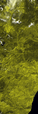
Methodology
The ScanEx provided satellite images and performed their primary processing
(recognition of principal types of contours) and their transformation to
fit geographical projection. In order to recognize separate contours, special
software developed by the ScanEx, NeiroImitator,
was used. Due to the lack of knowledge of local nature peculiarities, just
four contour types were recognized.
The further landscape–ecological analysis of images was made by experts
of the Biodiversity Conservation Center. The obtained contours were abundant
and small due to relatively high resolution of the area. Therefore, they
were generalized in accordance with small number of their types (i.e.,
available information). Electronic layers of vegetation and fresh burns
were combined by means of Arc/Info with additional information layers,
boundaries of protected areas on the Russian Far East, hydrographic network
and administrative boundaries. Based on comparison with literature data
on neighboring areas, including the Botchinskiy Zapovednik, the following
portrait was obtained.
Results
The greatest area at the territory of the Sukpai is occupied by contours
referring to tracts of spruce–fir forests. They occur on elevated parts
of ranges, have complicate topology but, at the same time, are almost unfragmented
or (on periphery) are slightly fragmented, appearing almost as a whole
extensive area. This is already important in sense of nature conservation,
since areas of the similar area are almost absent in the region beyond
the limits of some protected areas. According to the landscape analysis,
the greatest area is occupied by natural (climate-driven) successions,
including their last stages with high stand quality and significant floristic
diversity. Pyrogenic and anthropogenic successions also have certain share;
their vegetation is at various stages of recovery. At this resolution and
information, it is impossible to distinguish different variants of successions
within the whole tract of spruce–fir forests.
The other type of contours easily recognized after processing is secondary
birch forests in the place of cut down forests. According to the results
of the landscape–ecological analysis, all of them represent first stages
of forest recovery after anthropogenic disturbances. They occur in lower
elements of relief, have small areas and, as separate fragments are scattered
among the spruce–fir woodland, especially on its periphery. Their floristic
diversity is insignificant and they do not have special value. However,
it is important they practically do not disturb the wholeness of more valuable
forest areas.
A special case is contours linked to areas where simultaneously co-exist
two types of succession series. Some of them confide to birch forest of
different age, while the others did to fir forest of different age. According
to the landscape–ecological analysis, both are different stages of the
vegetation recovery in the place of pyrogenic and (more rarely) anthropogenic
disturbances. On some plots, these are late stages featuring by relatively
high stand quality (typically larch) and significant vegetation richness.
Other areas are less valuable but they gradually transit each in other,
and it is impossible to reliably recognize them at the moment.
Preliminary Conclusions
Recognition made by satellite images and landscape–ecological analysis
showed that:
-
The large whole tract of spruce–fir forests of the Sukpai may have special
nature conservation value.
-
Properties of the spruce–fir woodland require more detail analysis.
-
Fresh burns occupy small area that disproves conclusions of local experts
about the loss of considerable forest areas (i.e., their less nature conservation
value).
-
For more objective evaluation of the state of larch and Korean stone pine
forests, additional analysis is required.
-
The Biodiversity Conservation Center is ready to participate in joint expertise
of nature conservation value of Sukpai ecosystems with any local interested
parties.
| RUS(koi8-r)
|домой
на ЦОДП|
|оперативный
анализ|карты|домой
на РПП|
| ENG |
home
B C C | Operative
Assessment | maps
| home
EMD |
|