 | |


| All about Russian forests | Russian NGOs Forest Club | Useful links | Site map | Site search |
|
| |||
| ||||
|
|
|
Atlas of Russia’s Intact Forest Landscapes IntroductionRussia, it is often said, is a country dominated by wild forest, virtually limitless, largely unpopulated, and still unaffected by human development. Even nature conservation experts often espouse this opinion, assessing the extent of “absolutely wild” areas at 2/3 of the forest zone of Russia. Some regions in Siberia and the Russian Far East are even said to be 90 percent wild, or more.No systematic study that assesses the degree to which the forest zone (or any other zone) of Russia is still intact in a natural state has ever been completed. All verdicts on the remaining amount of “wild nature” in Russia are based solely on purported expert opinion. Moreover, the areas of intact wilderness that still remain (including forest wilderness) tend to be regarded as a virtually unlimited reserve of exploitable resources. This work is the first attempt at mapping the large, unbroken wilderness areas that still exist in the forest zone of Russia. The term intact forest landscapes refers to large mosaics of ecosystems in the forest zone, still in their natural state, minimally affected by human activity, and unbroken by infrastructure. PurposeThe purpose of the atlas is to give an accurate picture of the current status of remaining intact forest landscapes in Russia, and of the boundaries of federally protected areas, using a mapping scale that is relevant to practical land management (approximately 1:1 million). Such information is relevant for at least two reasons:
The atlas will support the forest industry’s effort to exercise precaution in sourcing of wood from specific, ecologically sensitive areas. Definitions and CriteriaFor the purposes of this atlas, an intact forest landscape is an area with the following characteristics: (i) It is situated within the forest zone; (ii) It is large enough (see below); (iii) It contains a contiguous mosaic of natural ecosystems which may or may not be of different types; (iv) It is not broken or fragmented by infrastructure; (v) It does not display signs of significant transformation caused by human activity; and (vi) it has a natural fire regime.The following set of criteria was used to identify and delineate intact forest landscapes. 1. Smallest viable area of an intact forest landscapeThe size of an intact forest landscape is considerably important for its viability and quality. If fragments are too small, they do not allow all essential components of the intact landscape to be conserved in their pure, natural state. For vital populations of large predatory vertebrates to coexist with the full range of natural ecological functions in a boreal landscape (including fires), for example, considerable space is required – upwards of tens of thousands of hectares, sometimes as much as hundreds of thousands of hectares. Nor do small fragments provide sufficient protection against edge effects, i.e. the influence from transformed areas outside the boundary of the intact forest landscape.The following size criteria were used in this study:
2. Significant kinds of disturbanceThere is a notion that the world still contains areas that have never been exposed to human influence. In reality this is not true. Each and every place on Earth has at some time in history been exposed to human influence, either directly or indirectly. Any meaningful definition of intactness must reflect this fact. Intact forest landscapes are not wild in a strict, absolute sense – they are only the most well preserved specimens of wild nature that remain in the forest zone. Delineation of these landscapes involves drawing a line between more or less disturbed areas – between areas having been subject to “significant,” as opposed to “non-significant” or “background,” human influence. The latter should show no signs of significant transformation by human activity nor should it have been subject to industrial land use for the last six decades. In this study, all ancient types of human activity were considered as background influence and were treated as a factor in the evolution of today’s forest landscapes. The following more recent analogous activities were also classified as background influence:
3. Minimum time since disturbanceHuman activity has shaped the forests for millennia. People have been one of the predominant causes of forest fires since the very beginning of colonization. In some cases it is impossible to tell to what extent a structural feature in the forest landscape is the result of natural processes and to what extent it is the result of human influence, such as reindeer grazing or human-set fires. It is therefore reasonable to consider only recent human activities as disturbances along with any activities of ancient times that have radically shifted the balance between natural and anthropogenic influences on the forest.The beginning of the 1930s marked the beginning of significant disturbances. Earlier human disturbance has not been considered significant with regard to the natural dynamics of the forest landscape. This time was chosen due to some radical changes in the 1930s that had very significant consequences for the forest landscape:
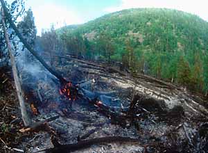
4. Forest firesForest fires, if ignited by lightning, are a natural part of the dynamics of boreal forest landscapes. Evidence of naturally occurring fires is available for practically all parts of Russia. Nevertheless, humans are the cause of most forest fires in Russia. The exact proportion of anthropogenic fires is not known. The official statistics contain a “fires of undetermined cause” category. Moreover, the classification of fires as “caused by lightning” is often rather dubious. V.A. Ivanov (1985) writes in his review of forest fires that “as a rule, the analysis of the link between lightning and forest fire is based on visual inspection. Within the next few days after a thunderstorm all fires are classified as caused by lighting, without consideration of possible anthropogenic causes. It is likely that the portion of fires caused by lightning is overestimated. As shown by Ivanov, the currently used method does not produce consistently correct information on the cause of fires.Even though the amount of spontaneous fires is likely to be exaggerated, most authors point to the overwhelming dominance of anthropogenic fires (Zakharov, 1977; Noga, Tikhonov, 1979; Sofronov, Vakurov, 1981; Odintsov, 1995; Furyaev, 1996; Sergienko, 1996, 1999, etc.). The average proportion of anthropogenic fires is estimated to be 80-90 percent for Russia as a whole. The proportion of spontaneous fires is higher only in areas with a pronounced continental climate, such as the area around the Irtysh River and in Evenkia and Yakutia in northern Siberia, where it has been estimated that 33-67 percent of fires are spontaneous, depending on the time period (Noga, Tikhonov, 1979; Ivanov, 1985). However, the occurrence of fires is connected with population density and land use even in these areas (Valendik, Ivanova, 1996). The published statistical evidence shows that spontaneous fires may dominate in number only in unusual years and in remote regions. Land use is one of the main causes of forest fires. A considerable amount of fires were probably caused by people even in the distant past. Causes range from slash and burn agricul
The influence of a fire on a forest ecosystem does not depend on its origin, everything else being equal. It is not possible to deem by the characteristics of the fire scar if the fire was anthropogenic or natural. An individual fire caused by a tossed burning match or a hunter’s fire is fully analogous with a fire caused by a lightning strike at the same spot. Single fires, regardless of their origin, that are not associated with the modern intensification in land use, can therefore reasonably be treated as a component in the natural dynamics of the forest landscape and a factor in its historical formation. The situation is different, however, for an entire forest landscape. Here it is the fire regime that is important, especially the frequency and typical site location of individual fires. These factors are associated with characteristics of the fire regime, such as fire intensity, pattern of distribution, and type (ground or crown fire). A fire regime at equilibrium (more or less) over a long period of time will produce a pronounced structure in the boreal landscape. There will be areas shaped by frequent fires, but also fire refuges – spots, which for various reasons escape fires for long periods (such as wet sites along rivers and creeks). Together, such areas form a mosaic that influences the biological diversity and the sustainability of the landscape as a whole. The increase in fire frequency caused by modern land use affect the fire mosaic of the landscape. The area of forest in an early succession stage will increase, fire refuges will decrease in numbers and may even disappear, the water balance will change along with the soil permafrost horizon, and the intensity of erosion, etc. Although the effect of individual fires does not depend on their origin, the combined effect on the landscape of all anthropogenic and natural fires is very different from that of a natural fire regime. The increase in fire frequency (or frequency of ignitions) caused by modern, intensive land use has caused abrupt changes in the affected landscapes. These changes are the result of significant human disturbance. A typical case is the abundance of fire in areas where oil, gas or gold is extracted, where geological surveying is conducted, and along transportation corridors. Intensified land use and expansion of infrastructure increase the fire activity in a landscape. The post-fire succession of burned areas may also be affected. If a fire scar, whether from a natural or anthropogenic fire, reaches a road or other piece of infrastructure, the regeneration on this site is likely to develop differently than it would without that influence. The probability of non-natural disturbance is greater, such as another fire, the introduction of non-indigenous (to the site) species, etc.
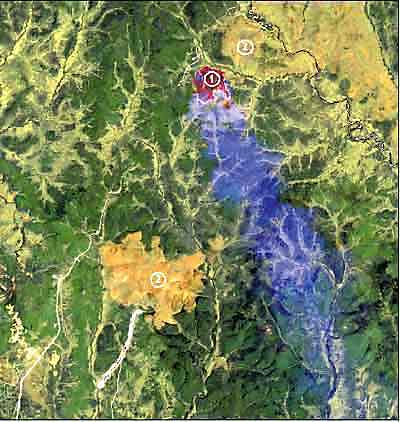
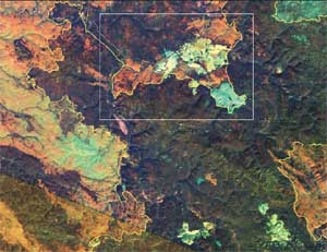
Even though the amount of spontaneous fires is likely to be exaggerated, most authors point to the overwhelming dominance of anthropogenic fires (Zakharov, 1977; Noga, Tikhonov, 1979; Sofronov, Vakurov, 1981; Odintsov, 1995; Furyaev, 1996; Sergienko, 1996, 1999, etc.). The average proportion of anthropogenic fires is estimated to be 80-90 percent for Russia as a whole. The proportion of spontaneous fires is higher only in areas with a pronounced continental climate, such as the area around the Irtysh River and in Evenkia and Yakutia in northern Siberia, where it has been estimated that 33-67 percent of fires are spontaneous, depending on the time period (Noga, Tikhonov, 1979; Ivanov, 1985). However, the occurrence of fires is connected with population density and land use even in these areas (Valendik, Ivanova, 1996). The published statistical evidence shows that spontaneous fires may dominate in number only in unusual years and in remote regions. Land use is one of the main causes of forest fires. A considerable amount of fires were probably caused by people even in the distant past. Causes range from slash and burn agriculture, hunting, reindeer herding, and later logging, mining, charcoal production, and transportation (Ponomarenko, et al, 1996). The influence of a fire on a forest ecosystem does not depend on its origin, everything else being equal. It is not possible to deem by the characteristics of the fire scar if the fire was anthropogenic or natural. An individual fire caused by a tossed burning match or a hunter’s fire is fully analogous with a fire caused by a lightning strike at the same spot. Single fires, regardless of their origin, that are not associated with the modern intensification in land use, can therefore reasonably be treated as a component in the natural dynamics of the forest landscape and a factor in its historical formation. The situation is different, however, for an entire forest landscape. Here it is the fire regime that is important, especially the frequency and typical site location of individual fires. These factors are associated with characteristics of the fire regime, such as fire intensity, pattern of distribution, and type (ground or crown fire). A fire regime at equilibrium (more or less) over a long period of time will produce a pronounced structure in the boreal landscape. There will be areas shaped by frequent fires, but also fire refuges – spots, which for various reasons escape fires for long periods (such as wet sites along rivers and creeks). Together, such areas form a mosaic that influences the biological diversity and the sustainability of the landscape as a whole. The increase in fire frequency caused by modern land use affect the fire mosaic of the landscape. The area of forest in an early succession stage will increase, fire refuges will decrease in numbers and may even disappear, the water balance will change along with the soil permafrost horizon, and the intensity of erosion, etc. Although the effect of individual fires does not depend on their origin, the combined effect on the landscape of all anthropogenic and natural fires is very different from that of a natural fire regime. The increase in fire frequency (or frequency of ignitions) caused by modern, intensive land use has caused abrupt changes in the affected landscapes. These changes are the result of significant human disturbance. A typical case is the abundance of fire in areas where oil, gas or gold is extracted, where geological surveying is conducted, and along transportation corridors. Intensified land use and expansion of infrastructure increase the fire activity in a landscape. The post-fire succession of burned areas may also be affected. If a fire scar, whether from a natural or anthropogenic fire, reaches a road or other piece of infrastructure, the regeneration on this site is likely to develop differently than it would without that influence. The probability of non-natural disturbance is greater, such as another fire, the introduction of non-indigenous (to the site) species, etc. In this study, fire scars were identified directly in the satellite images. The cause of a fire scar could not be determined, however. A decision rule therefore had to be constructed, so that the fire regime associated with each fire scar could be classified in a consistent way as either “natural” or “anthropogenic” (the latter were considered disturbed landscape). The following rule was created: All areas in which fire scars or fire mosaics (including areas with young forest vegetation) occur directly adjacent to a source of disturbance such as infrastructure or some other conduit of human activity were assumed to have an “anthropogenic” fire regime. They were therefore classified as disturbed landscape, even though some of these fires most likely were of natural origin. Such sources of disturbance include settlements, roads, clear cuts, industrial facilities, and rivers wider than 60 meters. Areas of otherwise intact forest landscapes, in which fire scars or fire mosaics do not reach any of the sources of disturbance mentioned above, were considered as having a “natural” fire regime. They were therefore classified as intact (even though many of these fires probably were caused by careless hunters, tourists, etc.). The authors are aware of the artificial nature of this classification of fire regimes. A consistent rule was needed, however, and this necessitated a pragmatic approach. All radical options were less attractive. Excluding all fire scars from intact forest landscapes was problematic. Fires are a natural element in the dynamics of a boreal forest landscape, and many typical forest landscapes owe their appearance to past fires. On the other hand, it would also be a mistake to include all fires in intact forest landscapes. There are gigantic areas of fire-affected landscapes around current sites of “development activities” that differ fundamentally from the structure of an intact landscape. A schematic decision rule had to be used because there is no credible method for separating natural and human induced forest fires.
5. The northern boundary of intact forest landscapesThe northern edge of the forest can be very diffuse in northern Russia. Moving north, the trees get successively smaller and sparser. Thus, a genuine intact forest landscape often changes gradually into an equally intact tundra landscape. Drawing the northern boundary of a forest landscape is a delicate task under such circumstances. The outcome depends totally on the forest definition used and does not reflect any change in the degree of intactness.The boundary of so-called “high dense” forests given on topographical maps (and also indicated in this Atlas) was deemed not suitable to represent the northern boundary of closed forests (further referred to as the northern forest boundary). An analysis of medium resolution satellite images suggests that the topographical maps for these areas are partly out of date and include significant areas of southern tundra shrubs that are classified as forest. The northern forest boundary in European Russia and Western Siberia was drawn based on medium resolution winter images, using data from model sites with known characteristics. A tree covered area needed to exceed 20 percent canopy density and be more than 20 kilometers (12.4 miles) wide to qualify. More narrow strips of forest, (e.g., along river valleys) were thus considered part of the treeless tundra zone (and consequently not considered intact forest landscape) along with tree-covered areas of lesser canopy density. Directly adjacent treeless areas of other kinds, such as alpine areas and bogs, were also excluded from the forest zone. This method allows for the separation of forest tundra from forest in flat watersheds. It is not directly suitable for the rest of the country, however, because the lack of model sites and dramatic variation in illumination and snow depth, caused by the mountainous topography, make it difficult to interpret satellite images. A landscape approach was therefore used in Eastern Siberia and the Russian Far East. Proposed by Zvorykin and Parmuzin (1956), it takes into account a whole complex of abiotic factors (e.g., occurrence of permafrost) that influence the composition and structure of forest ecosystems. Here, the boundary of the forest zone was drawn along the boundary of closed high forests (i.e., typically consisting of trees with more or less straight, main trunks). Besides satellite images and topographical maps, a number of thematic maps (climatic, hydrological, geological, vegetation, and soil, along with the percent tree-cover map by the University of Maryland (DeFries, et al., 2000)) were used. In some regions, a high degree of transformation by land use has resulted in a significant shift of the forest boundary to the south (e.g., in the vicinity of Salekhard and the Viluy reservoir, and the area between the Lena and Viluy rivers). The natural fragments of forest that exist north of this line were not assessed for intactness due to insufficient information. These areas’ boundaries are shown on the final map as a separate category without any division into classes of intactness, in the same way as they appear on the 1:500,000 topographic map. 6. The southern boundary of intact forest landscapesIn the vast majority of cases, the intact forest landscapes identified in this study have a distinct southern edge of a clearly anthropogenic character. Often it is formed either by infrastructure or by agricultural land. Some areas in southern Siberia and the Caucasus Mountains are an exception to this rule. Here, moving south, the forest gradually changes into forest steppe or treeless steppe, or in some cases into treeless alpine areas, without any noticeable change in intactness. No boundary was drawn in these cases. Instead, all contiguous intact areas were unified into one landscape all the way to the southern boundary of the Russian Federation. The identification of intact landscapes outside the forest zone of Russia is a special task, which requires individual approach and additional research.7. Intact forest landscapes that go beyond the boundary of the Russian FederationSome intact forest landscapes continue beyond Russian borders into neighboring countries. Such landscapes were delineated if their total area exceeded 50,000 hectares (123,500 acres), regardless of the political boundary. The part located in Russia may thus be smaller than 50,000 hectares.
| ||||||
|
|