 | |


| All about Russian forests | Russian NGOs Forest Club | Useful links | Site map | Site search |
|
| |||
| ||||
|
|
|
Atlas of Russia’s Intact Forest Landscapes The Atlas in Brief
ResultsThe romantic notion of the Russian forest as an unbroken band of boundless wilderness is a myth. In reality, the taiga consists of fragments of wilderness, separated by areas affected – either directly or indirectly – by modern land use. Industrial forest harvesting and the fires that follow logging, agricultural use and road construction are the main causes of fragmentation and transformation in European Russia and the southern parts of Siberia and the Russian Far East. In Western Siberia and the northern parts of Eastern Siberia and the Far East the extraction of mineral resources (including prospecting and construction of transportation infrastructure) and the massive human-induced fires that accompany these activities have also caused fragmentation.Approximately 289 million hectares (26 percent of the forest zone) remain as large, intact forest landscapes in Russia. Approximately 5 percent of the intact forest landscapes are in areas with special protection at the federal level. Eastern Siberia is the part of Russia that is least affected by modern land use, with 39 percent of the forest zone still intact, followed by the Russian Far East (31 percent intact) and Western Siberia (25 percent intact). European Russia is the most affected (9 percent intact). Almost half of all intact forest landscapes are found located in five administrative regions in Siberia: the Republic of Sakha (Yakutiya), the Evenk Autonomous District, Krasnoyarsk Kray, the Khanty-Mansi Autonomous District, and Irkutsk Oblast. Seven regions have more than 50 percent of their area in intact forest landscapes: Nenets Autonomous District (100 percent), Koryak Autonomous District (88 percent), (Kamchatka Oblast (85 percent), the Republic of Altay (63 percent), Yamalo-Nenets Autonomous District (62 percent), Evenk Autonomous District (61 percent), and the Republic of Tuva (57 percent). 98 percent of the total area of intact forest landscapes is in the 29 regions that have at least 10 percent of the area in that category. Intact forest landscapes are completely missing from 49 of 89 administrative regions. The forest zone of Russia is made up of 6 ecoregions according to the global classification by WWF (Olsson et al, 2001). In half of these, more than 90 percent of the area is affected by modern land use, while only one (montane grasslands) has retained more than half of the area in intact condition. Most of the intact forest landscapes areas are in sparsely wooded and mountainous parts of Russia. More than 80 percent of the intact forest landscapes fall in one ecoregion: boreal forests/taigas. Most administrative and ecological regions of Russia lack a representative or sufficiently large system of protected areas within the remaining intact forest landscapes. Approximately 5 percent of the intact forest landscapes (14.4 million hectares) have special protection in various forms: zapovedniks (strict scientific nature reserves), national parks, federal zakazniks (sanctuaries and wildlife refugees), and federal nature monuments. More than half of protected areas (3.6 percent) are in zapovedniks. ConclusionsIntact forest landscapes are becoming a rarity in many parts of Russia, or have disappeared completely. Such is the case in most parts of European Russia and Western Siberia, and in the southern parts of Eastern Siberia as well as the Russian Far East. Remaining intact forest is broken into fragments, too small to sustain the full array of components and functions characteristic of a natural forest landscape. Important conservation values remain but were outside the scope of this study.Without decisive action within the next few years, intact forest landscapes may disappear within whole ecological regions and even vegetation zones. The situation is most serious concerning temperate broad-leaf and mixed conifer-broad-leaf forests. Such forests are practically extinct in European Russia. The same fate may befall the forests in the area surrounding the mountain range of Sikhote-Alin, which are Russia’s richest in terms of biodiversity. Decisions about the conservation and use of the remaining intact forest landscapes must reflect a complex range of ecological, social, and economical factors. The forest industry in these areas should observe precautionary measures and make it a priority to preserve large and representative areas of wild nature. This is especially important and urgent in European Russia and the Southern parts of Siberia and the Russian Far East. A reasonable strategy for these areas would be to set aside remaining intact forest landscapes for a limited time period, to allow optimal decision-making for future conservation and land-use. Next stepsThe work needs to be refined in some areas, based on more precise criteria and information. The fire regime classification should be improved and high resolution satellite images (such as Landsat ETM+) used for the entire territory, supported by adequate ground verification. Conservation values within intact forest landscapes should be mapped and described illustrated so that well-informed and balanced decisions can be made without delay about conservation and use. Conservation values must also be mapped outside of the intact forest landscapes, i.e. in the production landscape. Mapping must become more detailed and incorporate the kvartal grid of Russian forestry. A retrospective study would add knowledge on the global carbon cycle and form a reference for monitoring future changes. Areas considered as immediate priority for refined mapping of conservation values include the Ural Mountains and Southern taiga belt in European Russia (the Leningrad, Vologda, Kostroma, Kirov and Perm Oblasts), the Altay-Sayan area in Western Siberia, the Angara-Enisey and Baikal Lake areas in Eastern Siberia, and the Sikhote-Alin Range in the Russian Far East.PurposeThis atlas presents an inventory of intact forest landscapes (i.e. the remaining large, unbroken areas of pristine nature within the forest zone of Russia). This endeavor was carried out by a group of Russian non-governmental conservation and scientific organizations between 1999 and 2002 as part of the Global Forest Watch initiative. The purpose of the atlas is to provide an accurate picture of remaining intact forest landscapes in Russia, and the boundaries of federally protected areas, to allow decisions about these landscapes to become better informed and more balanced.In particular, the results are crucial to implementation of Article 4 of the Law of the Russian Federation On Environment Protection, which states that “priority objects for conservation are natural ecosystems, natural landscapes and natural associations, unaffected by anthropogenic influences” (unofficial translation). The atlas will also support the forest industry’s effort to exercise precaution in sourcing wood from specific, ecologically sensitive areas. Definitions and criteriaAn intact forest landscape is a landscape in the forest zone that is whole and natural, undivided by infrastructure and almost entirely unaffected by human activities. It is large enough to support viable populations of large predatory vertebrates and keep most of the territory free of edge effects (minimum 50 thousand hectares). It may, and typically does, contain a mosaic of ecosystems (i.e. it is more than a forest). It has a natural fire regime.MethodA three-step procedure was used to exclude non-intact areas and delineate remaining intact landscapes: Areas around human settlements and infrastructure were excluded along with residual fragments smaller than 50,000 ha, based on a 1:500,000 scale topographic map of Russia.Further exclusion of non-intact areas and residual fragments smaller than 50,000 ha, based on medium resolution satellite images (a country-wide mosaic of Resurs-O1 MSU-SK with 150 m resolution from the summer and winter seasons, and Landsat ETM+ Quicklooks with 300 m resolution). Most agricultural areas and clearcuts of various ages were excluded at this stage. Further exclusion of non-intact areas and residual fragments smaller than 50,000 ha, followed by fine tuning of boundaries, based on high-resolution satellite images (Landsat-7 ETM+ with a resolution of 30 meters, ASTER with a resolution of 15 meters, and Resurs-O1 MSU-E with a resolution of 35 meters. Satellite images from 1999 to 2001 were used and reflect the status of the landscape at the middle of year 2000. All satellite images were geo-referenced onto the 1:500,000 or finer scale topographical map. Forest inventory maps at various scales at the level of leskhoz (local office of the state forest management agency), other thematic maps and field data on the degree of disturbance were used at all stages of the analysis. In total, approximately 8900 Landsat-7 ETM+ Quicklooks, 1470 TERRA ASTER, 516 Resurs-O1 MSU-E, 771 Resurs-O1 MSU-SK and 262 Landsat-7 ETM+ scenes were used.
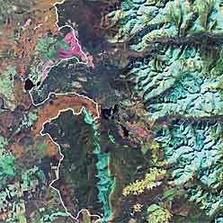
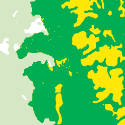
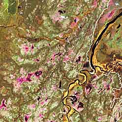
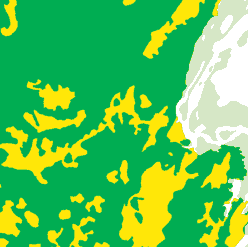
Picture 1. An Intact Forest Landscape, as the concept is used in this Atlas, is a large natural mosaic of untouched ecosystems located in the forest zone of Russia. The picture shows two different cases – one with mountains (top) and one with bogs (bottom) – of how the landscape is analyzed in a satellite image and represented on the map. Inside an intact forest landscape the maps use dark colors to show land cover:
Outside an intact forest area the maps use light colors:
Accuracy The maps of northern European Russia are most accurate (high resolution images and extensive ground verification - 173 sites). There is an intermediate level of accuracy in the Caucasus, central European Russia, and southern parts of the Ural area, Siberia and the Russian Far East (high-resolution images but insufficient ground verification or medium resolution images with reliable data from previous studies). The least amount of accuracy is in the northern parts of Siberia and the Russian Far East, some areas in the east of European Russia and in the south of Siberia (medium and partly high-resolution images, rare ground verification - 235 sites total for two last categories). The intact area is likely to have been overestimated where only medium-resolution images were used or ground data were insufficient. Review The draft atlas was presented in 2002 at review meetings in Krasnoyarsk (at the Sukachev Forest Research Institute), in Khabarovsk (at the Far Eastern Forest Research Institute), and in Moscow (at the International Forest Institute). Russian and international scientists and Russian government agencies were invited to submit written review statements.
| ||||||||||||
|
|